
Rapid Advances in Technology
When starting our Aviation business back in 2011, our first installation at Frankfurt Airport was quite a challenge. Not because of our system, which exceeded all expectations, but to measure the quality of simulation results for security or border control checkpoints, you need measurement data. At this time, automated counting solutions were not yet readily available, so we needed to do manual counting for evaluation purposes.
Ten years later, technology has evolved rapidly, and now multiple options are available for counting passengers and measuring queues in Airport terminals. The variety of solutions is so expansive that a clear differentiation between the use-cases and capabilities of each technology must be made.
This analysis of which technology to use can be resource-intensive and exhausting for airports that generally don´t have the required resources.
There is no one-size-fits-all solution, but LiDAR seems to cover most cases!
Therefore, Amorph Systems has focused on using LiDAR-based solutions in airports to address the broadest range of use cases shown below.
Why do we need continuous measurements?
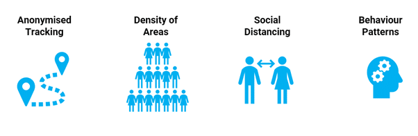
Meanwhile, measurement technologies have developed a lot, so the typical use-case of counting passengers entering a specific area and measuring queueing time is only one of a variety of use-cases. Due to the Covid-19 pandemic, the focus on density and social distancing has especially been intensified. For many airports, the complete tracking of passengers throughout the terminal environment is still on their wish list. This is not being done, partly due to technical and cost constraints, but primarily due to data privacy restrictions. Even with the data encryption process, tracking based on smartphone signals via WiFi is still viewed critically in many countries. LiDAR presents an appealing alternative as it doesn´t require information from any personal device and is by its nature GDPR compliant. Ideally, all this gathered information can be looped back into analytical systems to build and optimize predictive patterns based on behavioural descriptions.
LiDAR enables people tracking on a new level – totally GDPR compliant!
State-of-the-Art Technologies
As mentioned before, there are several technologies that have been implemented at airports for various use-cases. Typically, those are either 3D-Camera, CCTV-based or Wifi / Bluetooth-based approaches. Meanwhile, some companies merged the two to optimize the overall usability. However, both technologies actually have completely different capabilities for the gathering of data.
3D-Camera-based solutions need a picture to analyse a specific area. Queueing areas can be drawn, and algorithms are used to detect if a person is inside or outside an area. Based on these analytics, a queue length and an “actual” queue time can be calculated.
While 3D-Camera-based solutions provide relatively high accuracy, there are some disadvantages. To cover a certain area, the Camera view must be Top-Down, which leads to the following issues:
- The camera must be mounted on the roof or ceiling, sometimes resulting in high installation costs with high ceilings or open structures.
- Cabling may not be available or difficult to install at the required location.
- The camera coverage is limited to a certain area, meaning more cameras are required in situations where queuing outside of designated areas must also be measured.
- In the case of low ceilings, many cameras are needed, which will cost a lot to equip.
WiFi / Bluetooth-based technologies work based on the signals a smartphone/device is sending either to a receiver installed at a specific location or possibly via the WiFi network routers (where the network is equipped for this). Based on triangulation the location of a personal device can be determined, but the low degree of accuracy makes it difficult to pinpoint specific locations that are in close proximity.
How Does LiDAR Technology Work?
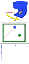
You might think of LiDAR as a similar technology to radar. The sensor uses laser beams that are sent out and reflected by objects. The reflection can be measured as a distance to the reflected object by the time the laser light needs to get back to the sensor. This creates a so-called “point-cloud” of a certain area.
This point-cloud itself is the source data for the subsequent identification and analysis of objects. As the sensors are used to answer certain business problems, software needs to be added that enables the further processing of the sensor data, such as object recognition or tracking of objects.
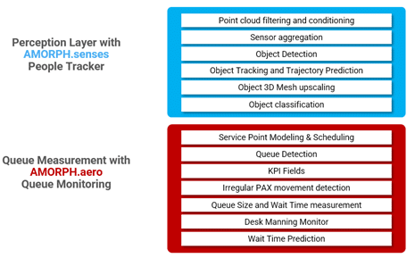
This is so-called 3D perception software is a key component as it determines the quality of the business analytics for the target use-cases. If the 3D perception is not high quality or is lacking certain features, the sensor itself might produce wonderful information, but will not enable addressing a specific use case.
As the last step, there is further processing to address certain business problems. If the target is to measure waiting times of an area like Check-In at an airport this means to detect persons, track them, and identify if they are part of a specific queue or not.
A LiDAR implementation is a 3-step process:
1. Hardware
2. 3D Perception
3. Use case-based algorithms
What´s the advantage of LiDAR?
So, is LiDAR the next gold nugget on the market? Sure, it is not. But LiDAR has the potential to significantly improve the way of measurement at airports.
First, it can be considered as an enhancement of existing installations. The typical setup of camera-based queue measurement systems has a limited view that does not extend beyond designated areas. LiDAR sensors have an extended view. With a range of up to 100 meters, a LiDAR sensor could identify potential queuing even beyond designated queuing areas in case of extraordinary crowds.
Second, in a greenfield environment, a LiDAR installation can be much more cost-effective than others. Especially in areas with low ceilings requiring dozens of cameras to cover an area, LiDAR can reduce costs significantly. With a maximum height needed of 3.5 meters, the sensors are able to cover a large area with a couple of sensors instead.
Finally, LiDAR is completely GDPR compliant. In contrast to Camera-based solutions which need to be processed on the edge and anonymized, LiDAR data is naturally anonymous. This enables tracking without the intrusion of personal data rights of passengers.
LiDAR can enrich check-point data to be more cost-effective and GDPR compliant.
Why AMORPH.senses enables flexible and cost-efficient measurement projects
To run a successful LiDAR project at your airport it is necessary to clearly evaluate the use cases to be addressed with a detection and measurement installation. Amorph Systems can provide expert know-how to design an optimal setup for your measurement project. In combination with our LiDAR expertise, we have years of experience with Camera and WiFi-based counting solutions and understand the pros and cons. Through AMORPH.senses, your platform for measurement analytics, customers are no longer in the hardware lock trap. Over are the days when airports we bound to a specific vendor for years, without the flexibility to adapt to new and less expensive hardware on the market.
AMORPH.senses enables agile and rapid deployment for cost-effective installations
Avoid the vendor lock of hardware suppliers
With AMORPH.senses, Airports are able to integrate latest state-of-the-art sensor technology, independent from the supplier.
Increase flexibility and lower costs
This will increase flexibility and lower costs as different types of sensors can be mixed to guarantee the best fit for purpose.
If you want to learn more about AMORPH.senses, LiDAR and how it could be applied in your airport please contact us.